

Why 2022 U-City flood could happen again thanks to warming temps
Published June 28, 2023
This story was commissioned by the River City Journalism Fund. This is Part II. For other chapters, see Ready or Not: St. Louis Grapples with Climate Change.
On the morning of July 26, 2022 the sound of dripping was the only sign that Alexis and Andre Rogers’ home would soon be inundated with water.
Alexis Rogers, half asleep, thought someone had left a faucet on. When the dripping sound woke up her husband around 4 a.m., he thought it was a weird time for his wife to be taking a shower.
They didn’t know a series of thunderstorms stretching across northeast Missouri and southwest Illinois had begun to dump more than 9 inches of rain in a belt about 6 miles wide and 250 miles long. The Rogers’ home, just a backyard away from the River Des Peres in University City, sat directly in the danger zone.

By the time Andre got out of bed, water covered the floor of the couple’s home. It reached up to his ankles.

Andre managed to kick his way through the flood and open the front door. He’d assumed the water was just in his house. When he looked outside, however, he saw a wave of water flowing down the street.
He and Alexis, who was several months pregnant at the time, gathered their children and fled to the attic.
“Luckily, we woke up in time because the water was close to getting inside her crib,” Andre says of his daughter.
About two miles away, Maxine Smith woke up to the same surprise.
Water had surrounded her bed when she woke to go to the bathroom around 3:30 a.m. A slight current carried plants and her kitchen trash can through a hallway in her University City ranch-style house into her room. They bobbed in the water like pool toys.
Worried about tripping over the debris, Smith quickly went back to her bed and laid down, wide awake. All she could do was wait.
“I didn’t know if it was going to rise and cover me,” Smith, 78, says of the flood water. “I didn’t want to go like that.”
The July 26, 2022, flood that decimated University City and other parts of the St. Louis area has gone down as one of the worst floods the region has ever faced. The city of 35,000 lost one life, a 60-year-old man who died as water submerged his car near Skinker Boulevard and Enright Avenue. A man also died in Hazelwood as he tried to leave his flooded truck.
All told, about 300 homes in University City were condemned. Those who haven’t moved out of the area are still trying to recover.
While the flood’s extremity may have seemed like an “act of God,” experts say it was only a small snapshot of what’s to come if we don’t take flood risk, and climate change, seriously.
Engineering into trouble
For decades, Bob Criss has sounded the alarm to deaf ears.
Criss, a hydrologist and professor emeritus at Washington University in St. Louis, says the way St. Louis has built around and engineered its rivers has set the region up for a grim future. Developments choke rivers. Urbanization has turned the area into a concrete metropolis where water can’t soak into the ground.
“We shouldn’t have done what we’ve done,” Criss says. “The only way to stop this problem is to quit what we’re doing.”
Sitting near the confluence of two of the mightiest rivers in the world, St. Louis is in a unique position. The Mississippi River alone is part of a drainage system that covers more than 1.24 million square miles, twice the size of Alaska. Flows in the St. Louis area can exceed 7.4 million gallons of water per second during severe floods.
The Missouri and Mississippi rivers served as the country’s original highways for travelers and remain vital for U.S. industry, but what began as small settlements along their banks gradually evolved into threats to nature that now choke the river.
The part of the Mississippi River near St. Louis is now half as wide as it’s been historically. Thousands of wing dams, or jetties of rock built on its edges, control sedimentation and slow water flow. Levees are now practically everywhere along its banks. Navigational depths for boats are maintained by occasional dredging. Riparian forests, or wooded areas that once served as buffers between land and water, have been destroyed consistently as early as the 1820s to prevent dead trees or branches from snagging steamboats.
“The river is entirely impounded, the wetlands are all gone,” Criss says. “The locks and dams have covered up all the lowlands with water. When you have water already, and if you add more water, where does it go? It’s got to flood.”
Hundreds of years of trying to change and control the river has only made it more of a threat. While floodwalls and levees are necessary with how close we’ve developed to rivers, they weren’t designed to withstand the changes to its climate that the U.S. is seeing — and will continue to see, Maisah Khan says.
“Climate change is dumping a lot more water into the system and in ways we can’t predict and haven’t seen before,” says Khan, the director of policy research for the Mississippi River Network. “Those structures were never built with that in mind.”
The next 100 years will bring even more water as environmental experts expect annual precipitation to increase and severe thunderstorms to become more common.
Annual precipitation throughout most of the Midwest has already increased by 5 to 10 percent in the past half-century. According to the U.S. Environmental Protection Agency, or EPA, the amount of water flowing in most streams during the worst flood of the year has increased by more than 20 percent.
Flooding has already become more common, but the reason for that varies by expert. Most agree climate change is at least part of the cause. As the earth warms (Missouri has already warmed by one-half to one degree, less than most states), air can hold more water.
“With higher temperatures, the higher potential for rainfall,” says Daniel Wright, an associate professor of civil and environmental engineering at the University of Wisconsin-Madison. “Climate change has and will continue to increase the severity, frequency and severity of extreme rainfall.”
While Criss acknowledges that climate change will make storms more intense and could especially affect smaller rivers and urban creeks, he thinks blaming climate change for flood risk is a cop-out.
“The elephant in the room is how we have built and where we have built,” Criss says. “I’ve been saying this for decades. We’d rather think it’s climate change — that this is happening to them and it’s not their fault.”
Concerned scientists like Criss have tried to bring area leaders’ attention to this for decades.
Scientists have warned since at least as early as the 1960s of the danger development poses to flood risk. In 1962, a St. Louis County Planning Commission study on flood evaluations noted: “As rapid urban development in St. Louis County continues, floods of greater magnitude will occur at more frequent intervals and damages will be increasingly severe if development is allowed in natural overflow areas.”
Local studies and other research have reiterated the same consensus throughout the past decade. But what’s been done throughout the area to mitigate flood risk is just a drop in a bucket — even as ongoing development in floodplains continues to make a bad situation worse.
On the banks of the River Des Peres
A year after last summer’s flood in University City, condemned homes still sit on Alexis and Andre Rogers’ side of the block. Here, on the southern side of Vernon Avenue in University City, a scent of mold wafts from the abandoned houses on warm days.
University City inspectors declared about 300 addresses condemned after last year’s flood. Of the 300, about 125 have been reinspected and resolved, according to University City Communications Manager Mary Goodman.
Those who remain on Vernon are mostly renters. Some only just returned to their homes a few months ago. Others are new and were unaware that a flood last summer turned their street into a raging river. (“There was a flood?” asks one resident when approached by a reporter.)
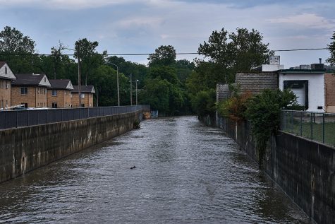
The Delmar Loop, one of the St. Louis area’s most bustling entertainment districts, is just a half-mile away. People live here because it’s close to restaurants, concert venues and stores. What they don’t know, or at least what most didn’t know until last summer, is that the river their homes abut is known as the “flashiest” river in Missouri, the River Des Peres.
Before it became the stinky feat of engineering it is today, the River Des Peres was a “common county brook, clear and attractive,” according to historical texts. A sulfur spring in the river near what’s now the Hill neighborhood housed a resort for city dwellers. As St. Louis’ population grew, urban runoff and sewage started dirtying the river in the 1800s. Some city dwellers emptied their chamber pots into it.
Yet flooding, not the smell and disease of the sewer, catalyzed a project to channelize the River Des Peres in the 1920s. By 1933, the once-thriving ecosystem of a river was engineered and regraded into the harnessed, open-air channel seen today.
Joseph Mallon thought the River Des Peres was a drainage ditch when he bought a house on Vernon Avenue for his daughter. He was told there was no flood risk. Mallon, a Florida native, didn’t believe it and tried to get flood insurance.
“When they told me I didn’t need flood insurance, I was like, ‘Are you crazy?’” Mallon says.
Even so, his preparation didn’t help; his application for flood insurance was denied. Mallon now plans on gutting the house and rebuilding to “hurricane standards.”
As for the Rogers, the water pushed a hole into their kitchen wall. Their landlord had to replace drywall up to about six feet throughout the single-story house. They spent a month cleaning up debris and mud; appliances, furniture and personal items had to be replaced. “I watched my 65-inch TV float away,” Andre Rogers says.
The family stayed in an Airbnb after University City officials slapped a condemnation notice on their front door without stepping inside. They were only able to return home in October, a few days before Alexis Rogers gave birth to their youngest son. Renters insurance provided no help.
“They don’t cover ‘acts of God,’” Alexis Rogers says. “That’s what they told me.”
The Rogers had no idea of any potential flood risk to their street.
Across the River Des Peres and directly south of Vernon Avenue, the homeowners on Dartmouth Avenue were equally unprepared.
Dartmouth Avenue is part of the historic University Heights subdivision. The houses are mostly owner-occupied and can sell for upwards of a half-million dollars.
Don Fitz, a former Green Party candidate for governor, had just moved from one house in the subdivision to another at the time of the flood. He says he lost about 90 percent of the books he’s been collecting for decades, some first editions, and altogether lost items valued at $65,000.
“It’s been traumatic for everybody, but some more than others,” Fitz says. “Some people lost their homes.”
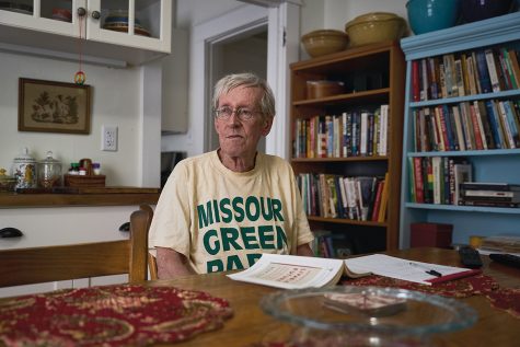
In the year since the flood, Fitz has taken on something of an activist role to spur flood preparedness in University City. He and several neighbors formed the Flood Task Force of University Heights to educate and advocate for flood mitigation efforts.
The task force recently asked the Washington University Environmental Law Clinic to draft legislation for University City on impervious surfaces. The bill would require property owners to use certain rainwater capture methods, including rain barrels or permeable pavement, to offset rain runoff caused by development.
It would also introduce a flood management fund, financed by fees paid by property owners who fail to offset stormwater runoff. Its proceeds would be used on projects to reduce flooding in University City. At least two University City councilmen would have to sponsor the proposal for it to appear on council agendas.
While walking down his street, Fitz points out the houses of former neighbors who’ve since moved away and the homes that people got trapped in.
When asked if he worries about another flood, Fitz says, “I’m worried we seem to have a do-nothing city council. We’ve told them about debris piling up there.”
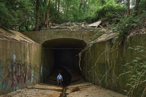
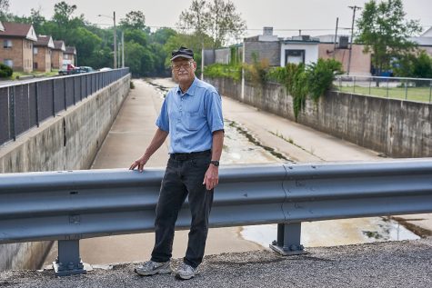
Between Dartmouth and Vernon avenues is the opening to a mile-long tunnel where the River Des Peres travels underneath Forest Park. Here, nearby residents theorize a whirlpool of water formed as water struggled to flow past debris that clogged the tunnel, which led to the area being one of the most heavily flooded parts of University City last summer.
Mallon says brush, sticks and yard waste get thrown into the river. “It’s just common sense” the tunnel would clog, he says.
Bess McCoy, manager of public affairs for the Metropolitan Sewer District, or MSD, says debris did not cause or contribute to last summer’s flood. The tunnel entrance is 20 feet by 21 feet in diameter and would require significant debris, like a car or truck, to affect flow.
“Per FEMA, this area is a designated floodplain … and with the amount of rain we received in last summer’s events, it did exactly what floodplains do,” McCoy says.
Either way, MSD does not own the upper River Des Peres, McCoy adds, and is not responsible for keeping it clear of debris.
Even so, she says, if the river’s concrete lining is in need of repair, MSD will make those fixes if it’s in an area where it has “maintenance authority.” Otherwise, it’s up to the property owners. Also, “If we are notified of major debris that could cause blockages like downed trees or large boulders, we will move those,” McCoy says.
Deterioration of the riverbank, including its concrete walls and culverts under roads, is expected over time, the Army Corp of Engineers noted in a 2022 study. This deterioration would possibly result in bank erosion and blockages of bridges and culverts.
In 2019, the University City Stormwater Task Force identified segments of the River Des Peres that included undersized and debris-clogged bridges and cited “significant” problems with channel clogging. The report determined some of the flooding problems in University City could be addressed by property owners, but any significant change would have to come from government agencies, such as the city, MSD, county or state.
They shouldn’t count on MSD. The agency does not have a comprehensive stormwater capital improvement program to fund such efforts. Voters haven’t approved funding to provide such services.
In 2019, voters rejected a proposed MSD rate hike that would have funded efforts to stop flooding and erosion. But MSD’s independent rate commission is currently considering a proposal to create a capital program through a 7.5-cent residential property tax and add an impervious surface rate for non-residential customers.
In the meantime, University City has hired an outside firm to prepare a stormwater management plan to minimize stormwater problems. They’ve also tapped the services of former U.S. Representative William Lacy Clay’s lobbying firm to drum up federal support for a water detention basin to hold water out of the River Des Peres during heavy rains. Clay’s firm, Pillsbury Winthrop Shaw Pittman LLP, is paid $8,609 a month plus expenses to find funding for an 8-acre water detention basin tentatively planned for Woodson Park in Overland.
“We never know when there’s going to be another historic flood, so we’re trying to do everything that we can to minimize flooding in this area,” University City Manager Gregory Rose says.
The Upper River Des Peres in University City has been the cause of significant damage for at least the past several decades, according to the Army Corps’ study.
Damaging floods occurred in 1957, 1970, 1973, 1978, 1979, 1980, 1981, 1982 and 1986, and more recently in 2008, 2011, 2013, 2014, 2019, 2020 and 2022.
This issue has been studied throughout the decades. Although area leaders say they’re working to mitigate flood damage, some residents moved away rather than risk enduring another flood.
Former University City Councilman Tim Cusick’s house was flooded for the second time last summer. It was worse than the first time, in 2008, he says. The stress caused Cusick to sell his home and move to Arizona.
“I couldn’t go through another flood like that,” Cusick says. “I did not feel safe.”
Over the years, several lists of homes for buyouts have been produced, according to Cusick, and his former house was on one of them. But the lists have been too long in the past, Cusick says. University City has shortened the list to boost its chances of approval from state and federal authorities.
“The money’s just not there,” Cusick says. “University City certainly doesn’t have the money for it. St. Louis County’s not going to pay for it. So we can’t do anything about it; there’s no money available.”
University City officials are still working on getting state and federal agencies to buy out properties inundated last summer. A combination of federal and city funds would pay for the buyouts, with University City providing a 25 percent match, according to Rose.
University City wanted to buy out nearly 300 homes after last summer’s flood, but the list was too long.
“We were told that would likely not get approved, that we needed to pare it down significantly, which is what we did,” Rose says.
After a massive flood in 2008, when two people on Wilson Avenue died, 26 properties on Wilson were given buyouts and demolished. Today, the only sign of the bought-out houses are the concrete dips where their driveways used to open to the street.
Some people whose homes were condemned last summer are waiting for buyouts and are stuck with homes that remain damaged or uninhabitable in the meantime.
“Unless you dam the whole river or remove it, those homes are still going to flood, no matter what,” Cusick says. “The only thing that can really be done is to buy those homes out and get those people out of harm’s way.”
The risk still doesn’t stop people from moving into flood-prone areas of University City — even those who are well aware of the risk.
On a recent Friday, Joe May and his family were moving into Cusick’s former home. He points to where the flood waters reached last summer, a line about four feet above the ground.
He’s well aware of the risk, but he found affordable flood insurance. And the house’s midcentury design and open floor plan (open enough for his two-year-old son to run through all the rooms in one big circle), check all the right boxes.
“It was an exact match,” May says.
Building on floodplains
During the flood of 1993, torrents of water surged through the Mississippi and Missouri rivers and their tributaries. It was the costliest flood in U.S. history. Fifty people died, at least 10,000 homes were destroyed and 1,000 levees were damaged. Damages totaled around $15 billion. Floodwaters inundated more than 15 square miles of land when the Missouri River overtopped the Monarch Chesterfield Levee in St. Louis County.
It could have been much worse.
Cold War-era radioactive waste sits in the Missouri River floodplain. Environmentalists speculate the failure of the Monarch Chesterfield Levee in 1993 protected the radioactive waste stored about a mile and a half away from the river in West Lake Landfill.
“The site would have flooded, no doubt,” says Dawn Chapman, co-founder of Just Moms STL, a grassroots organization that raises awareness about radioactive material throughout St. Louis.
Five levee districts trace the outskirts of the northwest corner of St. Louis County. The levees upstream from the district that protects West Lake, the Earth City Levee District, have been significantly fortified in the 30 years since the Great Flood.
Environmentalists worry that if a catastrophic flood stresses these levees again, it’s unlikely an upstream levee failure would again shield West Lake’s radioactive material from floodwaters.
This theory has been debunked by the Army Corps of Engineers, however. And Jerry Leigh of the Earth City Levee District says the levee that protects West Lake holds not because of events upstream, but because it’s so well-built.
The Earth City Levee was built to a 500-year standard, meaning it’s built to withstand water levels that might occur once every 500 years.
“It’s never gotten anywhere close to that,” Leigh says.
When asked about any potential flood risk to West Lake, the EPA downplayed concerns.
“Landfilling and other activities have significantly increased the topographic elevation of the site so that now most of the landfill is above the 500-year flood plain, including the areas with radiologically impacted material that will remain on site after the remedy is completed,” the agency said in a statement.
Since 1972, four major floods have tested the flood control system, including significant flood events along the Missouri River in 1993 and 1995, but no flooding has occurred at the site, the EPA further stated. The Earth City Levee is designed to withstand floods so large they have a 0.2 percent chance of happening each year.
Yet even if the levee holds during a flood, Chapman says, it might not matter. A nearby stream, Cowmire Creek, floods whenever the Missouri River rises.
“Some of the hottest areas where there’s surface-level radiation could be flooded when that creek backs up, and that creek backs up when the river rises,” Chapman says.
West Lake landfill is just one of several developments in a place where it shouldn’t be. FEMA’s flood hazard map shows mile after mile of homes, shopping centers, restaurants and even cities people have built where rivers would naturally flow.
In Chesterfield, two outlet malls (one largely unsuccessful) were built 20 years after the flood of 1993 submerged the area. Near Creve Coeur Lake, a developer is trying to build a residential and retail project that would bring about 800 apartments close to the lake’s northwest corner.
Renowned geologist Gilbert White coined “the levee effect” in 1945 to describe how flood control measures only increase potential losses. The sense of security from levees spurs development in flood plains, so when levees overtop or fail, the loss is greater.
“We’re making it worse all the time, rather than trying to correct the problem,” says Criss of Washington University. “And this is decades after the problem has been pointed out.”
An uncoordinated approach
Then there are the people who only learned about flood risk the hard way. For Arthur Loperena and Charles Redmon, their house in University City seemed like a safe buy when they bought it 45 years ago. Though they were told the house, which sits right across the street from the River Des Peres, was in a “semi-floodplain,” they were assured any flood risk to their home was minimal.
That seemed true until July 26, when a “raging river” flowed down their street, flooded their basement and cost them more than $100,000 to repair.
FEMA now designates their entire street as a “high risk zone.” According to Risk Factor, an online flood model that takes climate change into account, there’s a 71 percent chance of flood water reaching the couple’s house at least once within the next 30 years.
Now more aware of the risk, Loperena and Redmon, both retired and on a limited income, say they’re going to try to stick it out.
“We have no choice,” Loperena says. “We have nowhere else to go, no resources.”
While University City says it’s doing all it can to mitigate future floods, officials do so knowing their solutions may have detrimental effects on their neighbors downstream. Ultimately, the problem is greater than just University City — and any real solution will take a united regional approach.
“We’re hopeful that a regional agency will emerge that will take responsibility for maintenance, erosion control or stormwater master planning throughout the region,” Rose, the city manager, says. “All of those things should be approached through a regional basis.”
In the short to medium term, Jonathan Remo, a professor of flood hazard assessment and mitigation at Southern Illinois University Carbondale, says current levee systems are still functioning to a large degree.
“What this does is give people a sense of security that they’re always protected,” Remo says. “But as we’ve seen with climate change, we’re getting more extreme events. The levees and floodwalls we built in the mid-20th century did not predict this.”
The people who have money will be able to maintain their levees, and the people who don’t will lose their protection.
“We should have a coordinated approach to flood risk mitigation, but it just hasn’t happened,” Remo says. “We’ve been saying the same thing for oh, you know, almost 25 years now. It just doesn’t happen because there’s never enough political will at the end of the day.”
In the end, the river will win, Remo adds — but what if we let it win on terms that are better for us?
No one’s calling for St. Louis to demolish its levees and floodwalls. “No, that’s unrealistic, and that’s not going to work,” Khan, the policy director for the Mississippi River Network, says.
Still, there are other ways. Along any river, there are opportunities to build levee setbacks or move levees further inland so floodwaters could have a place to flow when needed.
“There are so many benefits,” Khan says. “You’d have places for recreation, where people could hunt or fish. When floods happen, it won’t hurt people.”
Whatever happens, it would take cities, counties and states to come together to prepare for the region’s future.
Criss isn’t holding his breath.
“We’re too selfish,” he says.
For more on the River City Journalism Fund, which provided funding for this project and seeks to support local journalism in St. Louis, please see rcjf.org.